
A promise to blog and a wonderful walk - a circular route at Mangaster.
- Gill Nadin

- Apr 27, 2019
- 4 min read
Although I’ve managed 3 blogs so far, I'm new to the idea and my blogging to date has been a bit erratic, so I'm going to try to blog every two or three weeks (maybe more, maybe less). I’ll announce each blog via a post on Instagram and Facebook – so please follow me there. If you find the first few interesting, please come back to check out the new material.
I'll have 5 broad topics for blogs.......
The first will be Shetland walks and walking suggestions - all based on walks that I've done, as I hate walking guides when you really feel as though the author has never been there!
The second topic will be practical - getting to Shetland, travelling around Shetland, the general geography of the islands and any other practical subjects – please see my last blog for driving on single track roads.
The third topic will be events throughout the calendar year and the fourth will be places you might wish to visit or things you might like to do while you’re here in Shetland – as well as go on a guided tour of course!
The final topic will be anything of general interest that I can’t fit into any other category.
Onto the subject of this blog......
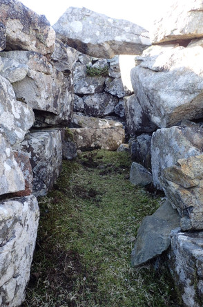
This walk will take us from Mangaster towards Nibon in the area known as Northmavine in the northwest corner of Shetland - map is at the end of the blog. The whole area has some stunning scenery, but this walk is particularly special. The walking is generally quite easy and for anyone used to hill-walking it’s not particularly challenging – meaning you can concentrate on the views. There are a few short steep inclines and you should be careful as much of the route follows exposed cliffs. After parking near the main road north of Brae at the junction with the minor road to Mangaster (grid ref HU333716), head past the houses and along the north edge of Mangaster Voe. Within about a mile you drop into a lovely small bay with a stream called Gills Burn entering in the bay. There’s a small old pier nestling in the bay. Above the pier is an old house at Pund of Mangaster. A pund is an enclosure for animals – there are several old stone walls here. The house has clearly not been lived in for many years. Local enquiries tell me it was last used as a summer house or weekend retreat about 30 years ago. It's such a shame to see old houses left and deteriorating, but it’s in a position that the only way to get renovation supplies to it would be by boat using the small landing jetty. The route across across the hills to the house wouldn't be possible with even a quad bike and putting a vehicle track to it would be so expensive, but it’s just such a lovely spot.


After exploring the old house and bay continue west dropping down again into Heo Dale opposite the small island of Egilsay. On the next headland of Heodale Head there is supposed to be the site of a medieval chapel, but there is little evidence of construction except an old pund on the cliff edge. Further along you pass the Black Skerry of Ramnageo, then past a lovely small inland loch and on up to a beautiful 7ft tall old stone cairn on Lang Head – not marked on the ordnance survey map, but a more stunning cairn I have yet to find. Like so many structures in Shetland, it is covered in lichen demonstrating the purity of the air here and we really do get some amazing lichen growth. I wonder how long the cairn has been standing and bearing in mind how wild the weather can be here on the North Atlantic coast, this cairn was clearly built to last. The views north have now opened up and the full extent of St Magnus Bay is visible, with The Drongs and Eshaness in the distance. It is worth a small detour away from the coast to Scarvie Loch tucked in its own little valley east of Lang Head.


During the next ½ mile section of the walk even more care needs to be taken around the exposed cliffs, some of which slope towards the edge. There is evidence of cliff falls and it's always something to be aware of in Shetland - cliffs are all unprotected and not all of them will be stable. The cliffs, natural arches and stacks around the natural amphitheatre of Mill Geos are spectacular and with the views north, this is really a wonderful stretch of coastline. Continue up to the cairn above Punds Loch for more great views, then drop down to the north end of the smaller of the 2 lochs where there is evidence of an old grain mill – you will find lots of these in all areas of Shetland. Now we start heading back to the starting point - follow the east side of the lochs and then cut across east to Brei Water of Nibon, then across Fellsa Moor and towards the west side of Punds Water (yes I know lots of the names are the same!).


At Punds Water there are 2 Neolithic sites (over 4000 years old) – the first is possibly a homestead and this large (10m diameter) structure has 5 internal compartments visible. Further on, the second is the largest remains of a heel-shaped burial cairn on Mainland Shetland – generally knee to waist-high with a façade about 20 m wide, you can still see the roofless chamber. It's always amazing to imagine life here 4000 years ago. From the cairn, head south-east to a new mobile phone mast and then drop down to the houses at Mangaster to re-join the road.


I really recommend this walk. Total distance about 7.5 miles and we took 4.5 hours, including a picnic stop. As with all walking in remote parts of Shetland, please take care and usual sensible hill-walking precautions – see our general advice about walking in Shetland.


Comments